
Cloud is a visible mass of water droplets or frozen ice crystals suspended in the atmosphere above the surface of the earth. Clouds give us a clue about what is going on in our atmosphere and how the weather might change in the hours or even days to come. Each type of cloud forms in a different way, and each brings its own kind of weather.
Cool Condensation
Clouds are water. As you probably know, we can find water in three forms: liquid, solid and gas. Water as a gas is called water vapor. Clouds form when water vapor turns back into liquid water droplets. That is called condensation. It happens in one of two ways: when the air cools enough, or when enough water vapor is added to the air. You’ve seen the first process happen on a summer day as drops of water gather on the outside of a glass of ice tea. That’s because the cold glass cools the air near it, causing the water vapor in the air to condense into liquid. Unlike the drops on the side of your glass though, the droplets of water in a cloud are so small that it takes about one million of them to form a single raindrop. Most clouds form this way, but the cooling comes not from ice in a glass, but as the air rises and cools high in the sky. Each tiny cloud droplet is light enough to float in the air, just as a little cloud floats out from your breath on a cold day.
Too Clean for Clouds?
Our air has to be just a little bit dirty for clouds to form. That’s because water vapor needs a surface on which to condense. Fortunately, even the cleanest air has some microscopic particles of dust, smoke or salt for water droplets to cling to, so the air is rarely too clean for clouds to form.
Common Cloud Types
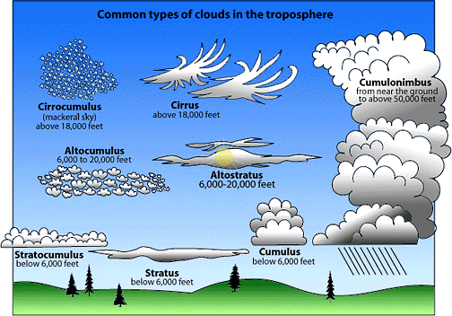
1.Stratus Clouds(Low Clouds)
It's Latin for "covering" or "blanket." Stratus clouds look like a flat blanket in the sky.
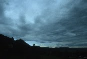
Stratus clouds are layered and cover most of the sky. They are much wider than they are tall. If you see them in broken or puffy layers, they are stratocumulus clouds. If you see them in thin high layers that turn the sky solid white, they're cirrostratus clouds. The tiny prisms of ice in a cirrostratus layer can bend the sun's light. As a result, often you can see a halo or veil of rainbow colors around the sun. When stratus clouds are very thick, they become dark nimbostratus clouds, which can produce rain, drizzle or snow.


2. "Alto" Clouds(Middle Clouds)
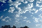
Altocumulus clouds are middle level clouds that are made of water droplets and appear as gray, puffy masses, sometimes rolled out in parallel waves or bands. The appearance of these clouds on a warm, humid summer morning often means thunderstorms may occur by late afternoon.
3. Cirrus Clouds(High Clouds)
It's Latin for "curl." Cirrus clouds look like curls of white hair.

Cirrus clouds are thin, wispy clouds blown by high winds into long streamers. They are considered "high clouds" forming above 6000 m (20,000 ft). Cirrus clouds usually move across the sky from west to east. They generally mean fair to pleasant weather.

Cirrostratus clouds are thin, sheetlike high clouds that often cover the entire sky. They are so thin that the sun and moon can be seen through them.

4. Cumulus Clouds
In Latin, this means "heap." Cumulus clouds look like a heap of cotton balls or whipped cream.
Cumulus clouds are low individual billowy globs that are low, have flat bases and look a little like cauliflower. They are at least as tall as they are wide and form on sunny days from pockets of rising air. Their constantly changing outlines are fun to watch because they can take the shapes of almost anything, including animals and faces. Cumulus clouds usually signal fair weather. If they build into the middle or high part of the atmosphere they get the name cumulonimbus. A cumulonimbus cloud is tall, deep and dark and can bring lightning, heavy rain and even severe weather such as hail, damaging winds or tornadoes. It is a sign of rapidly rising and sinking air currents.


Try to learn the names of the different clouds, and the next time you look up into the sky, take notice of what kind of clouds you see. And if you try, you might be able to guess what kind of weather they will bring.
Invest in Ripple on eToro the World's Top Social Trading Network.
ReplyDeleteJoin 1,000,000's who have already discovered smarter strategies for investing in Ripple...
Learn from established eToro traders or copy their positions automatically!